You are here
- Home
- blog_categories
- Disputed Landscapes
- Dawn of the Eco-drones? - Andrea Berardi
Dawn of the Eco-drones? - Andrea Berardi
7 May 2015

Usually only appearing in the news after they have been used to launch missile attacks or for military surveillance, drones have, until recently, had a bad press. Thanks to reduced costs and increased operational capabilities, however, the last decade has seen a rapid expansion in their application, with studies predicting that in 2021 their global market will approach US$4.8 billion (an eightfold increase from 2014 figures). In an interview with PSFK Gary Shapiro, president and CEO of the US-based Consumer Electronics Association, stated that drones:
are an economic game-changer – one that will transform the way we do business. Drones are already assisting emergency and disaster management programs, national weather service tracking, traffic management programs, shipment delivery and much more […]. People have seen the impossible become possible.
Faced with the increasing frequency of environmental disturbance and criminal activity, drones are also emerging as an important (and cheap – a battery-operated drone that can take high-quality aerial imagery costs less than £1000) tool for community members concerned with protecting their local environment.
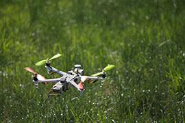
The technical term for a drone is an Unmanned Aerial Vehicle (UAV) but, for the purposes of this article, I’ll stick to 'eco-drone'. The simplest description is of a machine that can be flown by remote guidance (somebody on the ground directing) or autonomously (through a pre-programmed mission), while taking high-resolution photographs and videos of the landscape from a range of angles. Although many aerial images – for example those used by Google Maps – are already available online, most are under copyright and, in addition, may not have been taken at the right time or place. Eco-drones, however, would allow community members to capture higher-res images from different angles, enabling a complete 3-D investigation of their area of interest. Most crucially, the images can be taken at any time and, once the initial outlay for the eco-drone has been made, at zero cost.
Although some eco-drones can fly for 24 hours at over 730 km/h, covering distances in excess of 200 km, these typically cost over £100,000. For our purposes, then, I’ll focus on 'close-range' ones, which cost around £1000, can remain airborne for between 30 minutes and two hours, have a maximum speed of 60 km/h and a maximum range of 50 km. Their advantages include:
- Lightweight and easy to transport
- Low-cost, but produce high-resolution photographs and videos
- Can fly at a variety of altitudes depending on data collection needs
- Can rapidly and effortlessly map areas not accessible from the ground
- Offer quick availability of raw data.
Although low-cost eco-drones do offer some challenges, such as limited flight-time and payload, and the fact that software for advanced analysis of imagery requires expertise and can be expensive, they’ve had a range of successful uses to date. This includes:
- Mapping environmental change such as deforestation or urban expansion
- Managing disaster risk, for example floods, landslides or volcanic eruptions
- Monitoring illegal activity, for example poaching or illegal trade
- Surveying wildlife, including species migration patterns and population numbers.
The imagery collected includes Geographical Positioning System (GPS) coordinates, either from a GPS built into the camera, or, ideally, a higher-resolution GPS unit built into the eco-drone itself. These coordinates allow the imagery to be stitched together, like a mosaic, to provide a complete map of the whole area under investigation.
An excellent demonstration of the use of eco-drones to monitor deforestation and environmental degradation in a cost-effective and accessible way is offered in the South Rupununi, Guyana. Here, Digital Democracy, a US-based NGO, helped an indigenous community to construct and operate a fixed-wing drone which they then deployed to map the natural habitats around their village. You can read a full account in the case study: We Built A Drone.
A great advantage of eco-drones is that they bypass the need to physically trespass on private property or to confront criminals. However, as many countries, including the UK, don’t yet have comprehensive legislation to regulate their use, a precautionary principle is applied, requiring that operators keep eco-drones within their line of sight and at least 50 m away from people and associated infrastructure such as houses and roads. Eco-drones must also fly below 150 m in order to avoid collision with low-flying aircraft.
Over the next few years, we will most certainly see the rapid expansion of eco-drone deployment and a clarification of statutory regulation. In the meantime, communities can begin to apply eco-drones for environmental monitoring purposes through the application of the precautionary principle.
Andrea Berardi is a lecturer in Environmental Systems in the OU’s Department of Engineering and Innovation. He has qualifications in ecology, nature conservation and environmental sciences and is currently a co-investigator on Project COBRA, a €1.9 million EU project promoting indigenous solutions to emerging challenges in the Amazon. You can follow Andrea’s research and campaigns on Facebook and Twitter.
Share this page:
Contact us
To find out more about our work, or to discuss a potential project, please contact:
International Development Research Office
Faculty of Arts and Social Sciences
The Open University
Walton Hall
Milton Keynes
MK7 6AA
United Kingdom
T: +44 (0)1908 858502
E: international-development-research@open.ac.uk
.jpg)